Council sources innovative remote sensing technology to support water efficiency and disaster preparedness
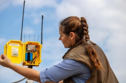
« Back- Council has developed several demonstration sites to showcase remote monitoring sensor technology and how it can assist local producers with water efficiencies and disaster preparedness
- The technology has been installed on water tanks within Council managed stock routes and reserves, as well as at key locations to measure water over public roads
- An explanatory video about the demonstration sites, the technology and potential applications to commercial primary producers is available on Council’s website
Goondiwindi Regional Council has introduced an initiative designed to showcase technology that enhances water efficiency and disaster preparedness for local primary producers. Considering the unpredictability in seasonal extremes, this project involves the installation of remote monitoring sensors on stock routes and reserve water tanks, as well as at strategic locations along public roads.
This technology enables Council officers to swiftly detect irregularities in water readings, resulting in significant water savings and cost reductions for maintenance and monitoring activities. This has led to the creation of several demonstration sites, where the technology's capabilities are showcased and its potential to enhance management practices is explained. This extends not only to local governments and disaster management teams but also to primary producers who stand to benefit significantly.
With a dry weather forecast looming over the region in the coming months, enhancing water efficiency is a top priority for Goondiwindi residents. This remote sensing technology equips primary producers with the ability to identify patterns in water readings and promptly detect leaks, thereby facilitating data-driven decision-making, all from the convenience of their smartphones or desktop computers.
As part of the Council's commitment to raising awareness of tools and resources for the community's drought and natural disaster preparedness, a comprehensive video about the demonstration sites, the technology in use, and its potential applications for commercial primary producers has been produced. The video is readily available on the Council's website: https://www.grc.qld.gov.au/residents/rural-services/home
Councillor Susie Kelly, who holds the portfolio for rural services, expressed her enthusiasm for the project, highlighting the technology as a practical means of support during periods of both drought and natural disasters.
"Remote sensing technology is a proven technology and has many applications. Investing in these demonstration sites to showcase the capabilities of remote sensing technology is an innovative way for Council to assist our local farmers in making informed decisions to strengthen their preparation in the event of a natural disaster," Cr Kelly said.
"The conventional approach of inspecting tanks and troughs or monitoring water levels in creeks often involves extensive travel and hours of manual checks. However, producers who adopt this technology gain the ability to access water data easily and promptly via their smartphone or computer," she said.